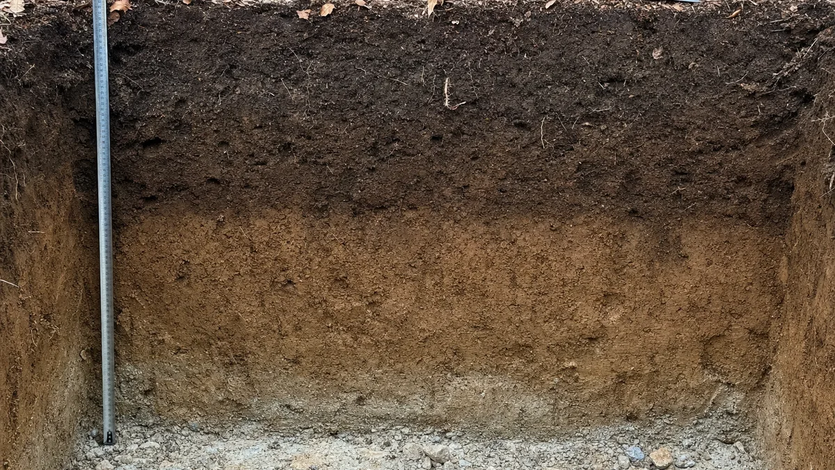
A soil profile is the arrangement of horizons, the layers of soil from the surface downward, according to the USDA Natural Resources Conservation Service. The six master horizons gardeners meet most often are O, A, E, B, C and R. NRCS says most soils have three major ones, the surface (A), the subsoil (B) and the substratum (C), and for a gardener the top layers matter most, because that is where roots, organic matter and soil life are concentrated. If you are building a bed above the ground instead, our guide to how to fill a raised garden bed covers what goes in it.
Soil Profile Quick Facts
| What | Answer | Source |
|---|---|---|
| Master horizons gardeners meet most | O, A, E, B, C and R; bedrock (R) is not soil | USDA NRCS Soil Survey Manual, NRCS education page |
| Most soils have | Three major horizons: A, B and C | USDA NRCS |
| Topsoil depth | The first 4 to 8 inches of soil | University of Maryland Extension |
| A horizon thickness | As little as 2 inches on a mountainside, about 2 feet on a former Illinois prairie | University of Illinois Extension |
| Where most roots are | In the topsoil (O and A horizons) | NC State Extension |
| Depth to bedrock, very shallow to very deep | Under 10 inches, 10 to 20, 20 to 40, 40 to 60, and over 60 inches | USDA NRCS Iowa |
Soil Profile Labeled: What Each Letter Means
Soil scientists label the master horizons with capital letters. The table gives the NRCS description of each one, what it means in a garden, and any depth figure we could verify. No NRCS or extension source we found gives a standard thickness for the O, E, B, C or R horizons, so the table does not invent one.
| Horizon | What NRCS says | In a garden | Depth |
|---|---|---|---|
| O | Dominated by organic soil materials | Fallen leaves and decomposing plant material at the surface, present only in some soils | No standard thickness found |
| A | Mineral horizon formed at the surface or below an O horizon; every soil has one | The primary mineral layer for root growth; with any O layer, it is the topsoil | Topsoil is the first 4 to 8 inches (Maryland); A horizons range from 2 inches to 2 feet in Illinois examples |
| E | Mineral horizon whose main feature is the loss of silicate clay, iron and aluminum | A pale, leached layer, common in soils formed under forest, such as those in eastern Iowa | No standard thickness found |
| B | Mineral horizon that typically formed below an A, V, E or O horizon | The subsoil, with more clay washed down from above, harder to dig and harder for roots to enter | No standard thickness found |
| C | Mineral horizon or layer, excluding strongly cemented and harder bedrock | Weathered parent material just above the bedrock | No standard thickness found |
| R | Strongly cemented to indurated bedrock | Solid rock, which NRCS says is not soil | NRCS Iowa classes soils by depth to bedrock, from under 10 inches to over 60 inches |
The Soil Survey Manual’s definitions are in Chapter 3, “Examination and Description of Soils.” The plain-language descriptions in the garden column come from University of Illinois Extension and NRCS Iowa. The A and B layers of one soil can have different textures, and a jar test on each shows it.
Diagram of a Soil Profile
The diagram below is an original schematic drawn for this guide, not a copy of an NRCS graphic. It stacks the six horizons from the ground surface down. The band heights are not to scale, because a real profile can be a few inches deep or many feet deep. A soil that has no E horizon simply skips that band.
Read it from the top. The thin dark O band is leaf litter, the same kind of material that rots down in a compost pile, which our guide to what you can compost covers. The A band below it is the topsoil, where roots and organic matter are densest. The E band, when present, is the pale layer that has lost clay and iron. The B band is the subsoil, and the C band is the weathered material the soil formed from. The R band is bedrock.
What the Layers Mean for Your Garden
Roots live in the topsoil
NC State Extension says topsoil, the O and A horizons together, usually contains less clay but more organic matter and air than the layers below, and has the greatest concentration of plant roots. University of Maryland Extension agrees, saying topsoil contains most of the organic matter, plant roots, and microbial and animal life. University of Illinois Extension calls the A horizon the primary mineral soil horizon for root growth.
Subsoil is harder going
University of Illinois Extension says the B horizon contains high amounts of clay that have leached out of the A horizon, making it more difficult to dig and for plant roots to penetrate. NC State Extension adds that subsoil usually has a higher clay content and lower organic matter content than topsoil.
Compaction and hardpans
Maryland Extension describes hardpans as compacted soil layers impervious to water, air and nutrients that can occur at any depth. It also gives a simple drainage check: water that drains slower than 1 inch per hour is too slow, and the cause can be compaction, high clay content, buried debris, a high water table or a restrictive soil layer. Soil that stays wet is also where roots rot, as our root rot guide explains. Our guide to soil bulk density shows how to put a number on how tightly packed your soil is.
New houses often lose their topsoil
Maryland Extension notes that topsoil is typically removed during construction, which is why urban and suburban soils are often altered. If your yard was graded for a house, the A horizon may be thin or missing. One response is to add topsoil or build a raised bed, and both start with working out how much material to buy.
For a closer look at the difference between bagged topsoil and garden soil, read our guide to topsoil vs garden soil, and for what a lab report says about the layer you are growing in, see how to read soil test results.
Why Soil Profiles Vary From Garden to Garden
No two gardens have the same stack of layers. University of Illinois Extension gives two examples of how far the A horizon can differ: it may be only 2 inches deep on a mountainside but could be 2 feet deep on a former Illinois prairie. Slope, vegetation, the rock a soil formed from and decades of farming or building all shape what is under your feet.
Depth to bedrock varies just as much. NRCS Iowa sorts soils into five classes: very shallow is less than 10 inches to bedrock, shallow is 10 to 20 inches, moderately deep is 20 to 40 inches, deep is 40 to 60 inches, and very deep is more than 60 inches. In a very shallow soil there is little room for roots to go down, so the depth of soil you add on top matters more.
NRCS Iowa also points out that the E horizon is mostly a forest-soil feature: soils in eastern Iowa that formed under forest vegetation commonly have one. That is why a gardener on former prairie or farmland may never meet an E layer at all.
Make a Mini Soil Profile
NRCS publishes a simple activity, “How to Make a Mini Soil Profile,” that models the layers you would see in a real soil pit or roadside cut. It builds the picture on a small card, and it is a good way to see your own layers side by side.
- Prepare a card. Use cardstock or a 3 by 5 inch note card.
- Add tape. Stick a strip of double-sided tape, about three-quarters of an inch wide, down the card.
- Sprinkle the soil from the top down. Start with the surface soil and work down in the order the layers sit in the ground, pressing each one gently onto the tape.
- Tap off the excess. Tilt the card to shake off loose soil, and store the finished card in an envelope.
NRCS notes that horizons differ in visible traits such as color, texture, structure and thickness, while chemical and mineral content need lab tests. So a card shows you the visible differences, not the nutrients.
Common Soil Profile Mistakes
- Expecting every soil to have all six. NRCS says most soils have three major horizons, A, B and C. An O horizon is present only in some soils, and an E horizon mostly appears in soils formed under forest.
- Treating topsoil depth as a fixed number. Maryland Extension says topsoil is the first 4 to 8 inches, while Illinois Extension gives A horizons from 2 inches to 2 feet. Check your own.
- Calling bedrock soil. NRCS is explicit that R, hard bedrock, is not soil.
- Judging a layer by color alone. A dark layer looks rich, but NRCS says chemical and mineral content need lab tests. A soil test, not a glance, tells you what to add.
- Ignoring compaction below the topsoil. A hardpan can sit at any depth, and water that drains slower than 1 inch per hour is a warning sign according to Maryland Extension.
For the wider topic, see our complete guide to soil and amendments, and for how much soil a new bed needs, see our guide to soil for a 4x8 raised bed.
Free book · 23 pages, PDF
Soil Profile FAQ
How many levels of soil are there?
NRCS calls the layers horizons. The six master horizons gardeners meet most often are O, A, E, B, C and R, and the Soil Survey Manual lists a few specialised ones as well, such as V. NRCS also says most soils have three major horizons, the surface (A), the subsoil (B) and the substratum (C). Bedrock (R) is not soil, and the O and E horizons are present only in some soils.
What is a soil cross section?
It is the side view you get from a soil pit or a roadside cut, with the layers stacked from top to bottom. NRCS calls the arrangement of those layers the soil profile, and each layer a horizon.
Can I use a soil profile picture from the NRCS website?
Check the credit line first. USDA says most information on its website is public domain and asks for credit as U.S. Department of Agriculture, but some materials are protected by copyright and may need permission. The NRCS A Soil Profile page shows a graphic with no credit or license statement, so we did not reuse it and drew our own.
How do I make a picture of soil profile layers from my own soil?
Follow the NRCS mini soil profile activity: press soil onto a strip of double-sided tape on a 3 by 5 inch card, starting with the surface layer and working down. The card models the layers you would see in a soil pit, and you can photograph it. It shows visible traits such as color and texture, not nutrient levels.
Which soil layer do plant roots use most?
The topsoil. NC State Extension says the O and A horizons together have the greatest concentration of plant roots, and University of Illinois Extension calls the A horizon the primary mineral soil horizon for root growth. The B horizon is harder for roots to enter because of its clay.
Is topsoil the same as the A horizon?
Nearly. NC State Extension groups the O and A horizons together as topsoil, so the A horizon is the mineral part of it. University of Maryland Extension puts topsoil at the first 4 to 8 inches, but University of Illinois Extension says an A horizon can run from 2 inches to 2 feet, so the depth depends on the site.
Sources & further reading
Horizon definitions come from the USDA NRCS Soil Survey Manual, Chapter 3: Examination and Description of Soils. The plain-language descriptions, the three major horizons and the mini profile steps come from the NRCS A Soil Profile page, the NRCS How to Make a Mini Soil Profile activity and NRCS Iowa’s From the Ground Down, which also gives the depth-to-bedrock classes.
Garden guidance comes from University of Illinois Extension’s Soil Basics, University of Maryland Extension’s common soil problems and the NC State Extension Gardener Handbook chapter on soils and plant nutrients. Image rules come from the USDA policies and links page. All pages were read in October 2026. For how we source the facts behind every guide, see our methodology page.
Free book · 23 pages, PDF
The Soil & Amendments Cheat Sheet
Sent